


Jerusalem (Hebrew: יְרוּשָׁלַיִם (audio) (help·info), Yerushaláyim; Arabic: القُدس (audio) (help·info), al-Quds)[ii] is the capital[iii] of Israel and its largest city[2] in both population and area,[3] with 732,100 residents in an area of 125.1 square kilometres (48.3 sq mi) if disputed East Jerusalem is included.[1][4][iv] Located in the Judean Mountains, between the Mediterranean Sea and the northern tip of the Dead Sea, modern Jerusalem has grown up outside the Old City.
![clip_image001[10]](http://lh5.ggpht.com/ismed08/SPS-4ROn2II/AAAAAAAAAG0/56IroEbODY8/clip_image001%5B10%5D%5B2%5D.jpg)
View of Jerusalem from the Mount of Olives
by Juancri, http://commons.wikimedia.org/wiki/Image:JerusalemFromMountOfOlives.JPG, and used under GNU Free Documentation License
The city has a history that goes back to the 4th millennium BCE, making it one of the oldest cities in the world.[5] Jerusalem has been the holiest city in Judaism and the spiritual center of the Jewish people since the 10th century BCE,[6] contains a number of significant ancient Christian sites, and is considered the third-holiest city in Islam.[7] Despite having an area of only 0.9 square kilometer (0.35 square mile),[8] the Old City is home to sites of key religious importance, among them the Temple Mount, the Western Wall, the Church of the Holy Sepulchre, the Dome of the Rock and al-Aqsa Mosque. The old walled city, a World Heritage site, has been traditionally divided into four quarters, although the names used today — the Armenian, Christian, Jewish, and Muslim Quarters — were introduced in the early 19th century.[9] The Old City was nominated for inclusion on the List of World Heritage Sites in danger by Jordan in 1982.[10] In the course of its history, Jerusalem has been destroyed twice, besieged 23 times, attacked 52 times, and captured and recaptured 44 times.
![clip_image001[6]](http://lh6.ggpht.com/ismed08/SPS-83Y-RcI/AAAAAAAAAG8/sw3lkkGB3Ck/clip_image001%5B6%5D%5B2%5D.jpg)
View of Jerusalem from the roof terrace of the Austrian Hospice
Copyright Guggani, http://commons.wikimedia.org/wiki/Image:Austrian_Hospice_Jerusalem_April_2007.JPG, used under Creative Commons Attribution ShareAlike 1.0 License
Religious significance
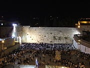
The Western Wall, known as the Kotel
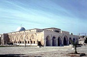
The al-Aqsa Mosque, the third holiest place in Islam
Jerusalem plays an important role in Judaism, Christianity, and Islam. The 2000 Statistical Yearbook of Jerusalem lists 1204 synagogues, 158 churches, and 73 mosques within the city.[134] Despite efforts to maintain peaceful religious coexistence, some sites, such as the Temple Mount, have been a continuous source of friction and controversy.
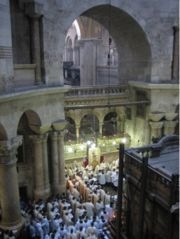
Church of the Holy Sepulchre
Jerusalem has been sacred to the Jews since King David proclaimed it his capital in the 10th century BCE. Jerusalem was the site of Solomon's Temple and the Second Temple.[6] It is mentioned in the Bible 632 times. Today, the Western Wall, a remnant of the wall surrounding the Second Temple, is a Jewish holy site second only to the Holy of Holies on the Temple Mount itself. Synagogues around the world are traditionally built with the Holy Ark facing Jerusalem and Arks within Jerusalem face the "Holy of Holies". As prescribed in the Mishna and codified in the Shulchan Aruch, daily prayers are recited while facing towards Jerusalem and the Temple Mount. Many Jews have "Mizrach" plaques hung on a wall of their homes to indicate the direction of prayer.
![clip_image001[8]](http://lh3.ggpht.com/ismed08/SPS_K2dPkuI/AAAAAAAAAHc/Y1WBE62GFLM/clip_image001%5B8%5D%5B2%5D.jpg)
Western wall of Jerusalem
by Wayne McLean, http://commons.wikimedia.org/wiki/Image:Western_wall_jerusalem_night.jpg, used under Creative Commons Attribution ShareAlike 2.0 License
Christianity reveres Jerusalem not only for its Old Testament history but for its significance in the life of Jesus. According to the New Testament, Jesus was brought to Jerusalem soon after his birth and later in his life cleansed the Second Temple. The Cenacle, believed to be the site of Jesus' Last Supper, is located on Mount Zion in the same building that houses the Tomb of King David.Another prominent Christian site in Jerusalem is Golgotha, the site of the crucifixion. The Gospel of John describes it as being located outside Jerusalem,[143] but recent archaeological evidence suggests Golgotha is a short distance from the Old City walls, within the present-day confines of the city.[144] The land currently occupied by the Church of the Holy Sepulchre is considered one of the top candidates for Golgotha and thus has been a Christian pilgrimage site for the past two thousand years.
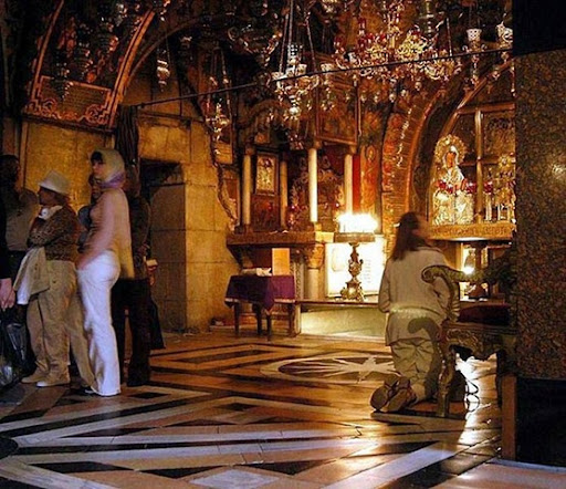
Golgotha Hill, inside the Church of the Holy Sepulchre
by Wayne McLean, http://commons.wikimedia.org/wiki/Image:Golgotha_hill.jpg, and used under Creative Commons Attribution ShareAlike 2.0 License
Jerusalem is considered the third-holiest city in Islam.[7] For approximately a year, before it was permanently switched to the Kabaa in Mecca, the qibla (direction of prayer) for Muslims was Jerusalem. The city's lasting place in Islam, however, is primarily due to Muhammad's Night of Ascension (c. 620 CE). Muslims believe Muhammad was miraculously transported one night from Mecca to the Temple Mount in Jerusalem, whereupon he ascended to Heaven to meet previous prophets of Islam. The first verse in the Qur'an's Surat al-Isra notes the destination of Muhammad's journey as al-Aqsa (the farthest) mosque, in reference to the location in Jerusalem. Today, the Temple Mount is topped by two Islamic landmarks intended to commemorate the event — al-Aqsa Mosque, derived from the name mentioned in the Qur'an, and the Dome of the Rock, which stands over the Foundation Stone, from which Muslims believe Muhammad ascended to Heaven.
![clip_image001[12]](http://lh3.ggpht.com/ismed08/SPS_Y7__w5I/AAAAAAAAAHs/4dyiSQelCAM/clip_image001%5B12%5D%5B2%5D.jpg)
The Western Wall with the Dome on the Rock in the background, Jerusalem.
by Nadavspi, http://commons.wikimedia.org/wiki/Image:WestWall-dome.jpg, and used under Creative Commons Attribution ShareAlike 1.0 License
Transportation
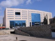
![]()
Jerusalem's Central Bus Station
The airport nearest to Jerusalem is Atarot Airport, which was used for domestic flights until its closure in 2001. Since then it has been under the control of the Israel Defense Forces due to disturbances in Ramallah and the West Bank. All air traffic from Atarot was rerouted to Ben Gurion International Airport, Israel's largest and busiest airport, which serves nine million passengers annually.
Egged Bus Cooperative, the second-largest bus company in the world, handles most of the local and intercity bus service out of the city's Central Bus Station on Jaffa Road near the western entrance to Jerusalem from highway 1. As of 2008, Egged buses, taxicabs and private cars are the only transportation options in Jerusalem. However, this will change with the completion of the Jerusalem Light Rail, a new rail-based transit system currently under construction. The rail system will be capable of transporting an estimated 200,000 people daily. It will have 24 stops, and is scheduled for completion in January 2009.
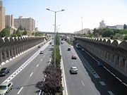
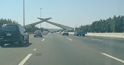
![]()
Begin Expressway.
Another work in progress is a new high-speed rail line from Tel Aviv to Jerusalem, which is scheduled to be completed in 2011. Its terminus will be an underground station (80m deep) serving the national Convention centre and the Central Bus Station, and is planned to be extended eventually to Malha station. Israel Railways operates train services to Malha train station from Tel Aviv via Beit Shemesh.
Begin Expressway is one of Jerusalem's major north-south thoroughfares; it runs on the western side of the city, merging in the north with Route 443, which continues toward Tel Aviv. Route 60 runs through the center of the city near the Green Line between East and West Jerusalem. Construction is progressing on parts of a 35-kilometer (22-mile) ring road around the city, fostering faster connection between the suburbs. The eastern half of the project was conceptualized decades ago, but reaction to the proposed highway is still mixed.
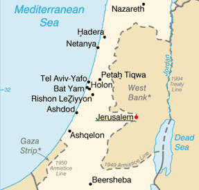
Map of Jerusalem

![clip_image001[4]](http://lh3.ggpht.com/ismed08/SPSnyA4WvsI/AAAAAAAAAGs/3C04hGdcfWw/clip_image00142.jpg)

![clip_image002[4]](http://lh3.ggpht.com/ismed08/SPSmnnvUh1I/AAAAAAAAAGc/Eoq-CGC322M/clip_image00242.jpg)


![clip_image001[4]](http://lh6.ggpht.com/ismed08/SPShR-c608I/AAAAAAAAAFc/53Nbk06J8vQ/clip_image00142.jpg)
![clip_image001[6]](http://lh4.ggpht.com/ismed08/SPShUa3enBI/AAAAAAAAAFk/g9dbrnqdZhI/clip_image00162.jpg)
![clip_image001[8]](http://lh4.ggpht.com/ismed08/SPShXJgDEFI/AAAAAAAAAFs/urWPdzuKUJQ/clip_image00182.jpg)
![clip_image001[10]](http://lh6.ggpht.com/ismed08/SPShZ9TuNxI/AAAAAAAAAF0/Gve41KQtwfU/clip_image001102.jpg)
![clip_image002[4]](http://lh6.ggpht.com/ismed08/SPR27GcpFCI/AAAAAAAAAEM/GBolnE48XTk/clip_image002%5B4%5D%5B2%5D.jpg)
![clip_image001[4]](http://lh3.ggpht.com/ismed08/SPR3wV11LtI/AAAAAAAAAEU/2Oyh845ucsc/clip_image001%5B4%5D%5B2%5D.jpg)
![clip_image002[6]](http://lh5.ggpht.com/ismed08/SPR30s8y14I/AAAAAAAAAEc/eIf98kQK7dU/clip_image002%5B6%5D%5B2%5D.jpg)
![clip_image001[6]](http://lh4.ggpht.com/ismed08/SPR363igN-I/AAAAAAAAAEk/x10d1k5L8n8/clip_image001%5B6%5D%5B2%5D.jpg)

![clip_image001[4]](http://lh3.ggpht.com/ismed08/SPRlJJ3Cj6I/AAAAAAAAADE/gmNC6pRJ2Ko/clip_image00142.jpg)
![clip_image001[6]](http://lh3.ggpht.com/ismed08/SPRlPq_InBI/AAAAAAAAADU/jxDi-4mxVss/clip_image00162.jpg)
![clip_image002[4]](http://lh3.ggpht.com/ismed08/SPRlbczta5I/AAAAAAAAADs/kHUeCDLpRrE/clip_image00242.jpg)
![clip_image003[4]](http://lh4.ggpht.com/ismed08/SPRlfBKD2-I/AAAAAAAAAD0/kgpmN0k2p0E/clip_image00342.jpg)


